With I-35 in Central Austin on course for its most dramatic transformation since opening in 1962, the city is scrambling to find hundreds of millions of dollars to blunt the impact of a multibillion-dollar highway widening.
The Texas Department of Transportation wants to add a pair of high-occupancy vehicle lanes in each direction between Ben White Boulevard and U.S. 290 East as part of the I-35 Capital Express Central Project.
Those bracing for disruption along the project's path have been fighting for resources to mute the effects of expanding an interstate through the middle of America's 11th largest city.
But so far, a once-in-a-generation attempt to conceal the highway under giant lids called "caps" has focused on a single part of the city: downtown.
"The North-Central residential areas have been really left out of the innovation that we're seeing in some of the downtown areas," said Brendan Wittstruck, who chairs the North Central I-35 Neighborhood Coalition, a group of a dozen neighborhood associations along the interstate.
Under TxDOT's plans, I-35's main lanes would be sunk 25 feet beneath ground level. The state agency produced schematics and illustrations showing the interstate capped from Cesar Chavez to East Eighth Street.

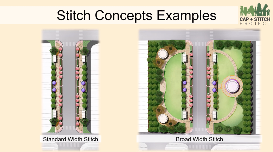
Some bridges would be widened to make room for extra pedestrian amenities on either side of the road. Officials call the widened bridges "stitches."

TxDOT will pay for the widened bridges, but Austin has to foot the bill for caps. Early estimates peg the city's portion at $700 million to $800 million. The cost includes the Cesar Chavez to Eighth Street covering, along with smaller caps at several locations and yet-to-be-determined public amenities on top.
"We're going to continue to refine those numbers," said Mike Trimble, director of the city's Corridor Program Office. He said he expected more details on the financial details and cap locations by early next year.

TxDOT plans to sink the main lanes through downtown to past Airport Boulevard, creating a wide range of opportunities for concealing the interstate beneath caps.
UT Austin is in talks with TxDOT over the possibility of capping I-35 from East 15th Street to about 30th Street. UT Austin declined to comment for this story, saying it was too early to know what involvement the university might have, if any.

Sinking the main lanes to Airport Boulevard will also mean tearing down the upper decks — elevated lanes that opened in 1975 — and widening the highway's footprint next to the Cherrywood neighborhood, enveloping businesses along the frontage road and pushing the right-of-way up to people's backyards.
In response, the Cherrywood Neighborhood Association drafted a proposal to cap the lowered main lanes from 32nd Street at least to 38th 1/2 Street. But so far, residents have struggled to gain traction with the city or TxDOT.

"What we're really asking for immediately is that TxDOT draw plans for this section of highway that allows for it eventually to be capped," said Brandy Savarese, vice chair of the Cherrywood Neighborhood Association. "If TxDOT designs the highway the way they are currently planning to design it, we can never cap this section."
TxDOT says its main concern with the Cherrywood North-Central deck proposal is access. The agency didn't make anyone available for an interview, but said in an e-mail that capping I-35 in Cherrywood could restrict ramps needed not only for operation of the high-occupancy vehicle lanes, but also for vital access to St. David's Medical Center at 32nd Street.

Cherrywood Neighborhood Association President Jim Walker says TxDOT is oversimplifying an engineering issue.
"There's still a lot of space there where you could add caps across. But we'd like a continued conversation. That's the period of the project we're in," he said.
The City of Austin is considering small caps over I-35 at 32nd and 38th 1/2 Streets that would build off the widened bridges, but it's a small improvement compared to what the neighborhood association wants.

"Multiple neighborhoods along the corridor would like to see as much as they can for their neighborhood and their community," Trimble said. "We understand that and we definitely are open to that."
Cherrywood has the most detailed proposal yet among the neighborhoods next to I-35, according to Wittstruck. But he says across the board, people want the daily impacts of the highway mitigated.
"They want the presence of it to be less in their lives. That could be safety. That could be noise. That could be air and water pollution," he said.
For example, Austin City Council Member Chito Vela — whose District 4 includes I-35 from Cameron Road almost to Braker Lane — is incensed that no major crossings are planned between 51st Street and U.S. 290 East.
"It is a huge distance in the middle of a major urban center," he said. "Completely unacceptable."
TxDOT has proposed a pedestrian-only bridge across I-35 near the Capital Plaza Shopping Center. Vela says that's not good enough.

"I do not want a dinky little pedestrian bridge that very, very few people will use. I want an actual east-west crossing that vehicles can use, that bikes can use, that pedestrians can use, so we can start to stitch together Windsor Park and Ridgetop, East and West Austin," he said.
As the I-35 widening is set to disrupt life along the highway and neighborhoods look for ways to take the edge off, the City of Austin is getting ready to launch a new round of public outreach over the cap and stitch plans, likely in the late summer or early fall.
Meanwhile, TxDOT will hold a public hearing on caps and stitches early next year. The state agency expects to have funding agreements with the city in place by next spring with payments for the caps due by the summer of 2024.
Construction on the I-35 expansion in Central Austin is scheduled to start in late 2025.


