Austin City Limits brings music-lovers from across the world to Zilker Park, who in turn bring traffic jams to the city. Lots and lots of traffic. Whether you’re attending the festival, dropping someone off or avoiding it altogether, here’s your guide on how to get around Austin for the next two weekends.
Road closures
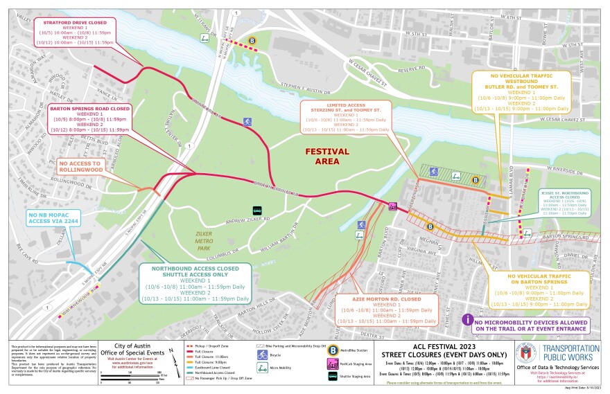
The major closures both weekends will be along Barton Springs Road (between MoPac Expressway and South Lamar Boulevard), Stratford Drive, Azie Morton Road and the northbound MoPac frontage road as you approach the area around the park.
Portions of Stratford Drive are already closed near Zilker Park for much of the day, from 9 a.m. to 6 p.m., and will remain closed through Oct. 20. The road will temporarily reopen Oct. 9-11, but will close again on Oct. 12.
Barton Springs Road has closed its westbound lane from 9 a.m. to 3 p.m., and will close the road entirely at 7 p.m. Thursday before each festival weekend.
A full breakdown of closures can be found here.

Getting around
Bus routes: CapMetro fares are $2.50/day. Its high-frequency routes include 2, 4, 7, 10, 20, 801, and run every 15-30 minutes. Buses will drop people off within a block of the free festival shuttle site at Republic Square. Use the CapMetro trip planner for directions.
Bikes: There are 75 CapMetro bikeshare stations around town. You can use any of the bikes to get to Republic Square or Zilker Park. The city will also offer free MetroBike valet off Toomey Road. You can find more info on the B-cycle app.
Scooters: These are ... everywhere! Download the Bird and Lime apps to find a scooter near you.
Rideshare: On your way to the festival, type in "Austin City Limits Music Festival" or "Zilker Park" into your app as your destination. To hail a ride as you leave the festival, you should walk away from Zilker Park, out of the restricted area first. Then you’ll be able to request a ride under the MoPac Pedestrian Bridge at Veterans Drive, Lee Barton Drive (between Riverside & Barton Springs Road), and Wallingwood Drive.
Parking: With the lane closures and number of people going to Austin City Limits, this should probably be your last resort. But if you do decide to park, you won’t be able to park at Zilker Park and you’ll have to reserve a spot in advance.
Walk: ACL Fest says this is one of the easiest options. If you don't mind a relatively short hike, you can follow the Hike and Bike Trail around Lady Bird Lake to Zilker Park.


