-
 Austin partnered with its flagship university to find which neighborhoods — and even buildings — pose the biggest threat of overheating during Texas' brutal summers.
 -
 A Reddit post showing paltry food conditions at Austin's Eighth Street Shelter led to online backlash.
 -
 Austin ISD and the University of Texas announced their campuses will remain closed Tuesday.
 -
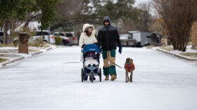 Travel is discouraged as accumulated sleet and freeing rain make roads, bridges and overpasses "extremely dangerous" and travel "near impossible in many areas."
 -
 Abbott issued disaster declarations Thursday for more than 130 counties ahead of a winter freeze expected to sweep into Texas over the coming days. "The goal is to make it through with no life lost," the governor said.
 -
 A photo appearing to depict the Republican U.S. senator on a plane went viral on social media, after Cruz famously left Texas for Cancún during 2021's deadly winter storm. A spokesperson for Cruz said Wednesday he "will be back in Texas before the storm is projected to hit."
 -
 The National Weather Service says the Austin area can expect freezing temperatures this weekend, along with wind chills in the single digits and the possibility of freezing rain or sleet.
 -
 Subfreezing temperatures are expected by Friday as arctic air moves into Texas, with some areas possibly staying below freezing through Monday before warming into the lower 40s on Tuesday.
 -
 Hundreds of newly published text messages add more detail to the devastating timeline of the deadly July 4 Texas floods.
 -
 Austin Mayor Kirk Watson and Travis County Judge Andy Brown say their winter weather plans include minimizing power outages, keeping roads safe and opening places for people to stay warm during the day and overnight.
© 2026 KUT Public Media
A service of the Moody College of Communication at the University of Texas at Austin
webmaster@kutx.org
A service of the Moody College of Communication at the University of Texas at Austin
webmaster@kutx.org
Play Live Radio
Next Up:
0:00
0:00
Available On Air Stations


