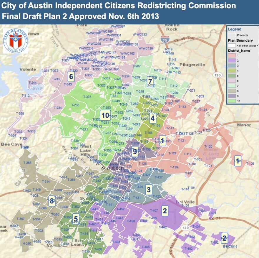
Update: Austinites have just two more opportunities to weigh in on a proposed city council district map.
A citizens group is dividing Austin into 10 geographic districts. Starting next November, each district will elect one city council member. Everyone will vote on the mayor.
The district-drawing group is expected to approve the final map soon.
Wednesday's public meeting is at The Lodge on Dawson Road in south Austin. It starts at 6:30 p.m.
Thursday's public meeting is at the Millennium Youth Entertainment Complex on Hargrave Street in east Austin. It also starts at 6:30 p.m.
Click here to see an interactive version of the "official proposed final map" drawn by the Independent Citizens Redistricting Commission.
Original Story (Nov. 7, 8:28 a.m.): After months of public input, on Wednesday a citizen-led commission approved a new version of a map of preliminary voting districts to be used for 2014 Austin City Council elections.
The Independent Citizens Redistricting Commission is in the process of splitting the city into 10 districts. City council members will now be chosen from each district while the mayor will be chosen by the city as a whole. (Currently, voters citywide elect the seven council members, including the mayor.)
Citizens have raised concerns in recent months that the preliminary map was not representative of the city’s communities. The latest draft map shortens District 7, which previously ran all the way from Parmer Lane to Lady Bird Lake. It also includes more of south Austin in District 5, removing the neighborhoods from District 9.
The changes also extend District 6, which includes parts of North Austin, to include a chunk of West Austin. And the map expands District 10, the West Austin and Mount Bonnell area, to include parts of 45th Street and Lake Austin Boulevard.
The draft map leaves the University of Texas area split. Most of UT lies in District 9. The district includes the West and North Campus areas, but leaves out students living on the other side of I-35 in East Campus. According to the redistricting group's website, students are "not a protected group under the US Constitution, the Voting Rights Act or the City Charter."
There will two more public meetings next week before a final vote on the district map. The committee hopes to adopt the plan by December 1.
Each district must be made up of approximately the same amount of people. Census data, not voting data, is used to populate the districts. All districts currently have about 80,000 people.
The Voting Rights Act requires the commission to ensure minority representation in the city districts. This means that districts considered minority districts must have a significant amount of underrepresented persons in the district – though minorities do not have to be the majority. District 1, the map’s African-American opportunity district, remained unchanged.


