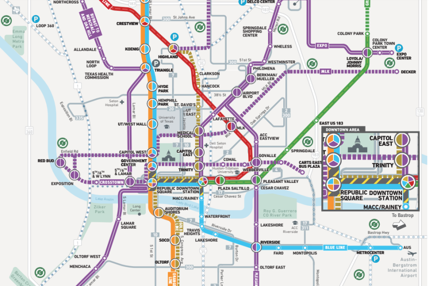
Three years ago this month, Austin was presented with a once-in-a-generation vision to transform the city's public transit system: a pair of light-rail lines stretching 28 miles with high-frequency service, a downtown subway and rapid connections to the airport.
The plan promised other transit upgrades like new MetroRapid routes run exclusively with electric buses and a commuter rail line to Northeast Austin. All of this was bundled into a $7.1 billion plan branded Project Connect.
The Austin City Council ordered a November 2020 election and approved what it called a "contract with the voters," vowing to build the citywide system. During the pandemic, with local transit ridership down by half, a majority of Austin voters signed up to raise their city property taxes by 20% — so promising was the dream for Austin's transit future.

Today, people are waking up to a different reality.
Five new light-rail options are being unveiled this afternoon at the Austin Central Library. Each is less than half the length of the original 28-mile vision. Gone are the plans for a 4-mile downtown subway with underground shopping. Only one of the five proposals goes to the airport.
Turns out, those early light-rail designs pitched to voters cost more than expected. Last year, the base estimate grew from $5.8 billion to $10.3 billion. So now, the plan is to build the system much more slowly.
Part of the shift has to do with who's in charge.
The Austin Transit Partnership (ATP) — a local government corporation created to finance and build light-rail — ousted its last chief, Randy Clarke, who developed the original plans with the soaring cost estimates. The ATP board replaced Clarke 10 months ago with a more fiscally conservative leader, the agency's lead money-cruncher and long-time city budget writer Greg Canally.
"Certainly, I understand that there was a vision," Canally told KUT. "You can't enact your vision all at once."
Canally got the ATP board's blessing in July to spend months paring down the original light-rail plans to fit in the advertised budget. The five options presented today are the result.
Each of the proposals is estimated to cost less than $5 billion, including a whopping 40% cost contingency. So while each plan is actually closer to $3.5 billion, the ATP is hoping the added cash cushion will make its pitch more appealing to the federal government. Project Connect still depends on the Federal Transit Administration shouldering up to half the cost.
"One of the key factors that the federal government looks at when they invest is to make sure that you have a plan not only now, but in the future," Canally said. "We are hearing now around the country where projects are getting canceled, and they're not receiving grants, because they have not done the right financial planning."
Austin's permanent transit property tax ensures a steady stream of cash — about $159 million this year and growing — to keep building the system after the smaller plan is up and running.
Canally says the light-rail system should open to the public in the "early 2030s." But he wouldn't estimate when the full vision dangled in front of voters in 2020 would be constructed.
"Our focus is on getting this first part of that vision done. Doing long-term work at this point we don't think would be the best use of tax dollars," he said.
Let's take a look at the five options.
UT to Yellow Jacket

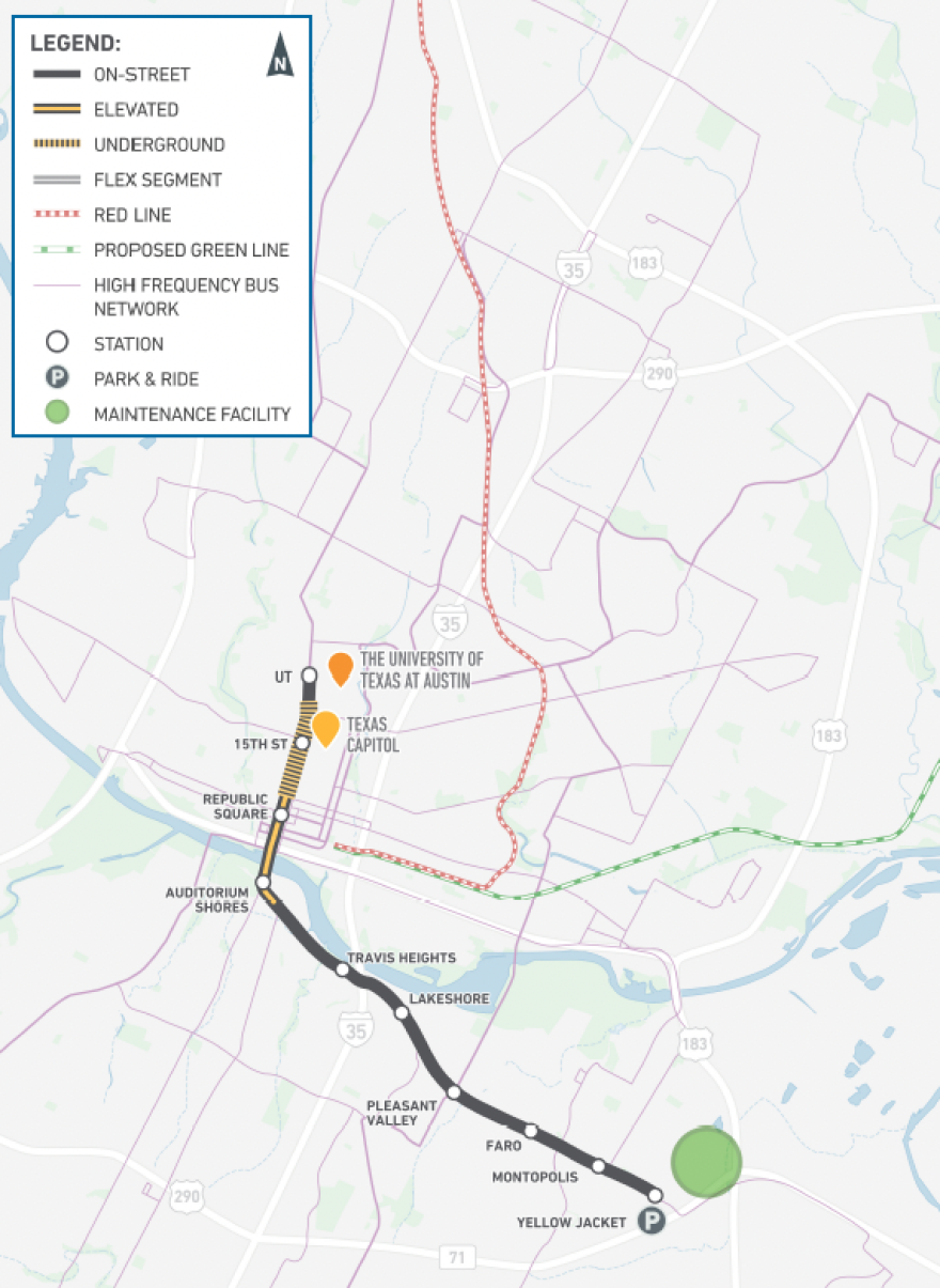
This is the only option that keeps an underground transit tunnel. But instead of a 4-mile system downtown, this tunnel would run about a mile down Guadalupe Street from 20th Street to south of Eighth Street.
One of the biggest changes in the ATP's new light-rail options, besides the shortening of routes, is the new prospect of elevated rail downtown. Lifting the rail off the street is less expensive than burying a subway and still allows trains to whisk over traffic lights and past Austin's intractable rush-hour gridlock.

The UT to Yellow Jacket route would have elevated rail from south of Eighth Street on Guadalupe to east of Auditorium Shores. The route would cross Lady Bird Lake at South First Street and travel down East Riverside Drive to Yellow Jacket Lane where there would be a park and ride.
29th to Oltorf to Yellow Jacket

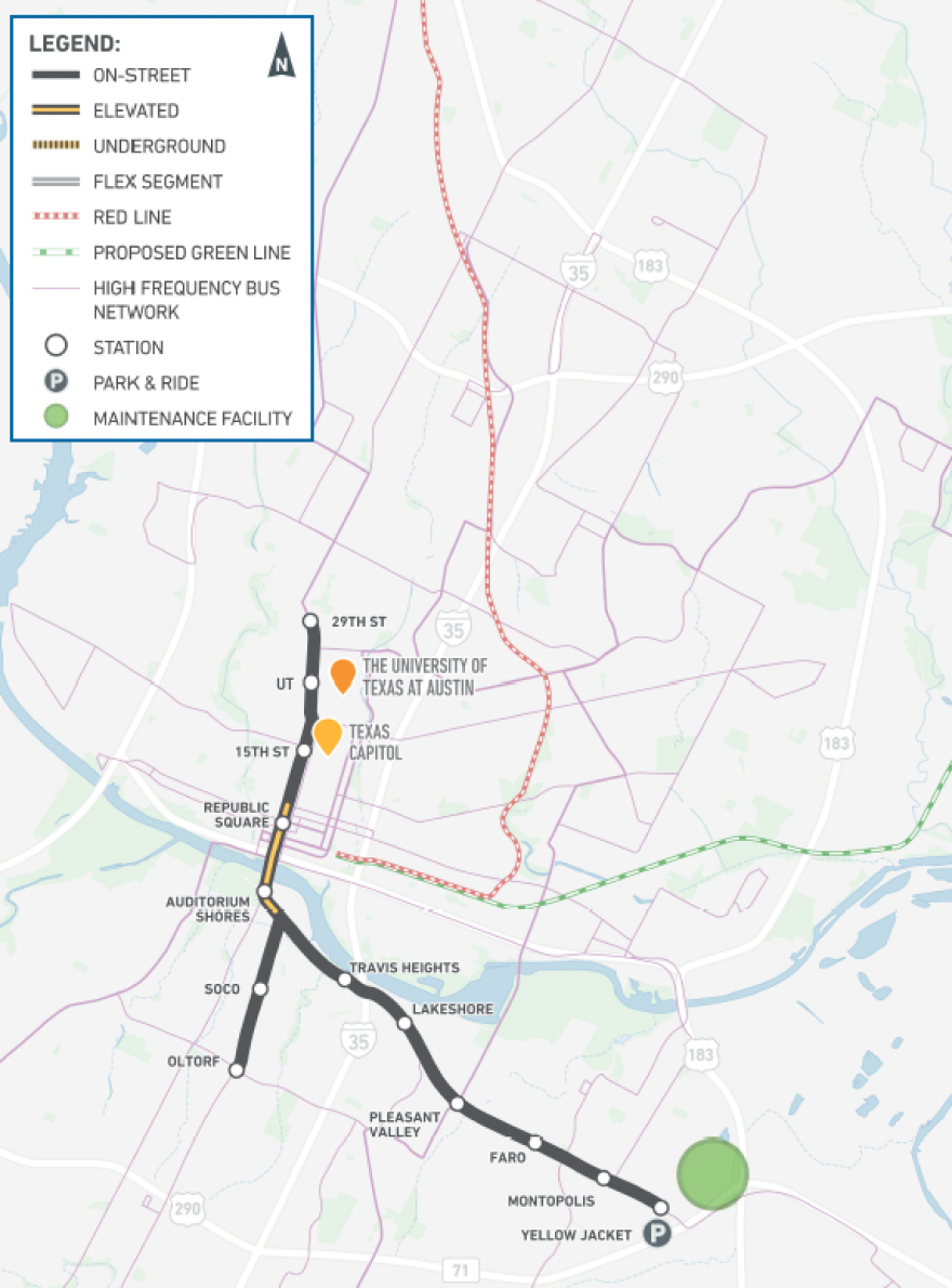
ATP's only other option including elevated rail downtown starts at 29th Street, runs down Guadalupe Street and separates from ground level just south of Eighth Street.
The raised tracks would cross Lady Bird Lake at South First Street and connect to an elevated station at Auditorium Shores.
After the Auditorium Shores station, the line would return to street level and branch into two different directions. One line would head down South Congress to Oltorf Street. The other would go down Riverside Drive to Yellow Jacket Lane.

29th to Airport

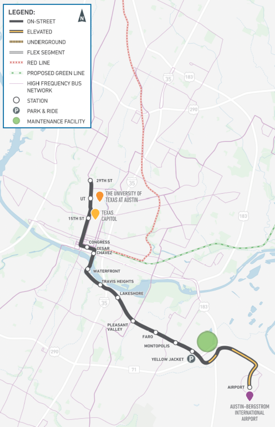
Only one of ATP's new light-rail options connects to Austin-Bergstrom International Airport. This line would start at 29th Street, head down Guadalupe Street, turn east at Third Street and cross Lady Bird Lake at Trinity Street.

The route would continue down East Riverside Drive. At Yellow Jacket Lane, the line would be mostly elevated the rest of the way to ABIA.
North Lamar to Pleasant Valley

The North Lamar to Pleasant Valley option is entirely at street level. The route starts at the North Lamar Transit Center and heads down Lamar Street and then Guadalupe Street to reach downtown.
The ATP is proposing two choices for downtown.
The first downtown option would have a station at Republic Square Park and cross Lady Bird Lake at South First Street to reach a station at Auditorium Shores.

The second downtown option would eliminate the Republic Square and Auditorium Shores stations. Instead, the route would turn east down Third Street to reach stations at Congress Avenue and Third and at Cesar Chavez and Trinity Street.

The route would cross Lady Bird Lake at Trinity Street and continue to Riverside Drive at Pleasant Valley.
38th to Oltorf to Yellow Jacket

This entirely on-street option not only includes two downtown configurations, but also asks people if the route should go farther north or farther south.
The ATP says the route could either start at 38th Street and Guadalupe Street and go as far south as St. Edwards University. Or the line could start farther north at 45th Street and end at Oltorf.
A second line, branching off on the south shore of Lady Bird Lake, would extend down East Riverside Drive to Yellow Jacket Lane.
The downtown options are similar to the configurations in the North Lamar to Pleasant Valley plan.
The first option would stop at Republic Square, continue across Lady Bird Lake next to the South First Street bridge and stop at Auditorium Shores.

The second option would send the line down Third Street, stop at Congress Avenue, and cross Lady Bird Lake at Trinity Street.

What's next?
The Austin Transit Partnership will collect public feedback over the next six weeks starting with tonight's open house at the Austin Central Library. You can also email input@atptx.org.
After hearing from the public, ATP officials will create a final recommendation to bring to the ATP board, Austin City Council and Capital Metro later this spring.
"Come get involved. Let us know what you think about these options," Canally said. "We want to use all that information as we move forward, but ultimately we're really excited about where we are."


