The Texas Department of Transportation is studying whether to build a four-lane highway along the same stretch of land where Austin is planning to break ground next year on a 12-foot-wide concrete trail.
Both projects fall within part of an old railroad route that shut down almost half a century ago. The 28-mile MoKan Corridor — traversing from East Austin to Georgetown — was named after the Missouri-Kansas-Texas railroad that operated from 1904 to 1976.
TxDOT bought the MoKan Corridor after the railroad shut down. The corridor, which varies from 60- to 160-feet wide, has for decades been eyed by local and state officials for transportation projects.
The state's latest plans — creating a test road for autonomous vehicles — came to light last week, sparking a furor among trail advocates and blindsiding some elected officials.
The state agency had asked the Capital Area Metropolitan Planning Organization (CAMPO) to reclassify the MoKan Corridor as a "principal arterial" — a category of major roads that includes MoPac and Ben White Boulevard.

Last week, trail advocate Tom Wald, executive director of the Red Line Parkway Initiative, was scrolling through the 171-page agenda for CAMPO's Monday meeting when he came across TxDOT's request.
"This is serious," Wald thought. "If that project ends up coming to fruition, what it would mean is a place people go to for serenity is no longer a place for serenity."
Wald was among those who sounded the alarm. A wave of complaints about TxDOT's project flooded Austin City Council inboxes. CAMPO received more than 1,000 emails expressing concerns.
"Who's asking for it? Where is the conversation? Because it's certainly not with the community and it's certainly not with the elected officials of the city," said Austin Mayor Pro Tem Paige Ellis, who sits on CAMPO's 22-member board.
"They definitely had to pump the brakes on the topic," she said.
Before board members could vote on the reclassification at their Monday meeting, TxDOT asked CAMPO to delete the item from the agenda.
In a statement to KUT, TxDOT said the request to designate the MoKan Corridor a principal arterial had been "premature."
"Functional classification is part of the process when developing a new corridor — was on the checklist and was added too soon," spokesperson Bradley Wheelis said in an email.
TxDOT is now vowing to do a round of public input before moving ahead with the plan.
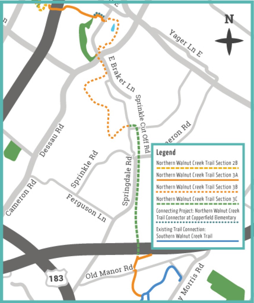
The Southern Walnut Creek Trail is built on the MoKan Corridor at various points from the U.S. 183 Boggy Creek Bridge toward U.S. 290 East. These sections would be converted to a four-lane road with a shared-use path under the plans TxDOT is considering.
Meanwhile, Austin is getting ready to break ground next year on Northern Walnut Creek Trail Section 3 — an 8-mile concrete path that in many places overlaps with the MoKan Corridor.

The city has already dedicated more than $15 million to building that section of the trail. Most of the money is from bonds approved by voters in 2016 and 2020.
But despite construction scheduled to start in 2024, Austin still has no formal agreement in place with TxDOT and would need one to move forward.
"Discussions are under way to seek approval to build the Northern Walnut Creek Trail Section 3 within TxDOT’s MoKan Corridor," said Cheyenne Dolin, a spokesperson with the city's Public Works Department.
The possibility of a road being built in the MoKan Corridor will come as no great shock to city staff. A preliminary engineering report for the Northern Walnut Creek Trail in 2019 acknowledged the corridor had been designated by the state as "multi-modal" and might even be used by Capital Metro for rail or buses.

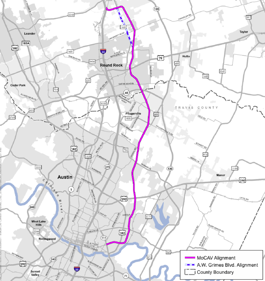
TxDOT has labeled its newest road concept MoCAV, short for Mobility for Connected and Automated Vehicles. The highway would run from about U.S. 183 in Austin through Pflugerville and Round Rock, and end at the CARTS bus station in Georgetown.
MoCAV would be four-lanes wide from U.S. 183 to Parmer Lane and at least two-lanes wide from Parmer Lane to Georgetown. TxDOT says the road would have lanes for automated vehicles and public transit but would also accommodate traditional passenger vehicles.
Capital Metro, which has studied the use of the corridor for everything from commuter rail to express bus service, says TxDOT's purchase agreement for the MoKan Corridor included a requirement that transit lanes be included.
"CapMetro is [partnering] with TxDOT to ensure transit services are included in opportunities being explored, and to ensure any project in the corridor is well coordinated with other transit investments," CapMetro spokesperson Blythe Nebeker said in an email.
MoCAV would also include a shared-use path for pedestrians and cyclists. But it's a small consolation to those who hoped for a more bucolic setting for the Northern Walnut Creek Trail.

"I think we just need more information about what they have in mind and what the impact would be," Nina Rinaldi with the Shoal Creek Conservancy said.
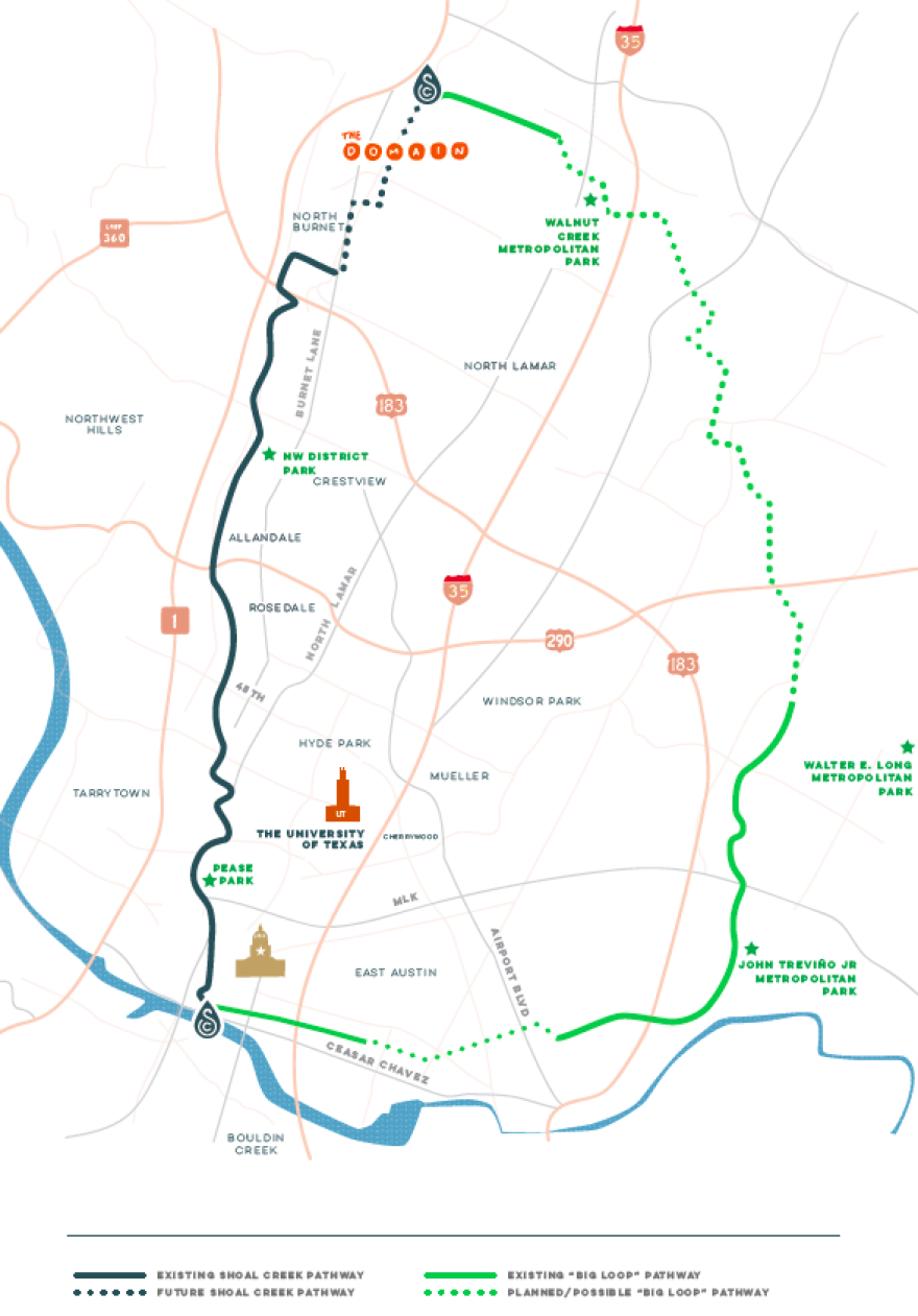
Rinaldi points out the Northern Walnut Creek Trail Section 3 is the most significant missing piece of the 30-mile "Big Loop" of planned bikeways and trails slated to traverse the city north of Lady Bird Lake.

Much of the MoKan Corridor lies in City Council District 1, which is represented by Natasha Harper-Madison. Her chief of staff, John Lawler, says they're concerned not only about MoCAV's potential impact on the trail, but also on what it would mean for surrounding residents.
"More than anything" Lawler said, "what we would like is an open and frank conversation with the state, with CAMPO and other regional partners about how this corridor could help or hinder improvements for those neighborhoods."


